Introduction to Satellite Orbital Types
|
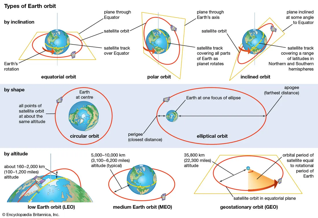
An orbit is the path of an object around a point in space. Orbits are commonly classified by their altitude, their inclination, and their eccentricity.
These classifications help us determine a satellite's function, the energy required to reach its orbit, and the area of Earth it can observe. |
 |
Classification by Altitude
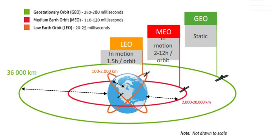
One of the most straightforward ways to classify an orbit is by its average height above the Earth's surface. This altitude directly influences a satellite's orbital speed and orbital period.
- Low Earth Orbit (LEO), ranging from about 160 to 2,000 kilometers above Earth, is the most accessible and densely populated orbital region. Satellites in LEO, including the Tiangong Space Station and many Earth observation satellites, travel at very high speeds, completing an orbit in roughly 90 minutes. Their proximity to Earth allows for high-resolution imaging and relatively low-latency communications, making them ideal for monitoring the planet and its climate.
- Medium Earth Orbit (MEO) is found between 2,000 and 35,786 kilometers. The most common use for this orbital band is for navigation and timing systems. The constellations of satellites that power the Global Positioning System (GPS) operate in MEO. From this altitude, they can cover a larger area of the Earth's surface than LEO satellites while still maintaining a manageable signal travel time.
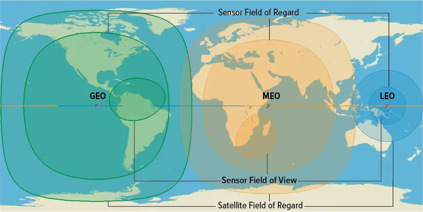

The region at an altitude of 35,786 kilometers is particularly significant and hosts two important types of orbits:
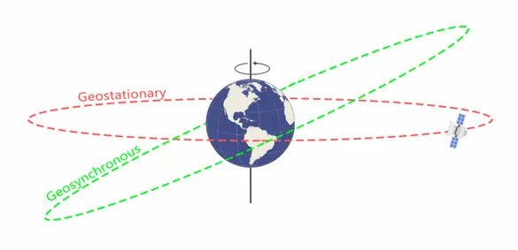
- Geosynchronous Orbit (GSO) is defined by its orbital period, which is exactly one sidereal day (about 23 hours, 56 minutes), matching the Earth's rotation. From the ground, a satellite in GSO appears to return to the same position in the sky each day.
- Geostationary Orbit (GEO) is a special kind of geosynchronous orbit. It not only matches the Earth's rotation but is also circular and has an inclination of 0 degrees, meaning it sits directly above the equator. This combination of factors causes the satellite to appear completely stationary in the sky. This characteristic is particularly useful for weather monitoring and communications satellites, as ground antennas can be pointed at a fixed point in the sky to maintain a constant link.
 |
 |
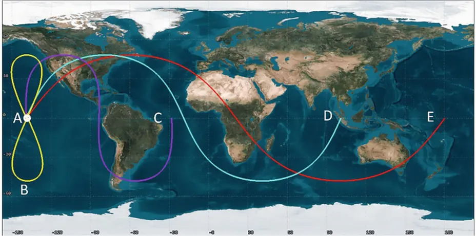
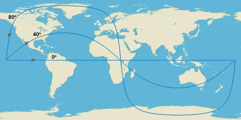
A: Geostationary Orbit (GEO), with orbital period = 24 hours
B: GeosynchronousOrbit (GSO), with orbital period = 24 hours
C, D, E: Inclined orbits with decreasing orbital period, and decreasing orbital altitudes
For Geosynchronous Orbit, since the orbit has some inclination and/or eccentricity, the satellite would appear to describe a more or less distorted figure-eight in the sky, and would rest above the same spots of the Earth's surface once per sidereal day.
B: GeosynchronousOrbit (GSO), with orbital period = 24 hours
C, D, E: Inclined orbits with decreasing orbital period, and decreasing orbital altitudes
For Geosynchronous Orbit, since the orbit has some inclination and/or eccentricity, the satellite would appear to describe a more or less distorted figure-eight in the sky, and would rest above the same spots of the Earth's surface once per sidereal day.
Classification by Inclination and Orientation
Orbital inclination describes the tilt of an orbit relative to the Earth's equator.
- Equatorial orbit has an inclination of, or very near, 0 degrees. The satellite follows a path directly above the equator. As discussed, the geostationary orbit is the most well-known example of an equatorial orbit.
- Polar orbit has an inclination of, or very near, 90 degrees. In this orbit, the satellite travels from pole to pole. As the Earth rotates beneath it, a satellite in a polar orbit can pass over almost every part of the globe over a period of time. This makes polar orbits effective for mapping, reconnaissance, and environmental monitoring satellites that require global coverage.
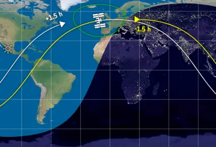
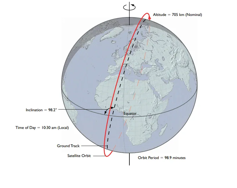
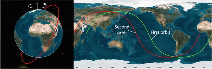
- Sun-synchronous orbit (SSO) is a specific type of near-polar orbit. Its orbital plane is tilted in such a way that the satellite always passes over any given point on the Earth's surface at the same local solar time. For example, a satellite might always cross the equator at 10:00 AM. This consistency in lighting conditions is valuable for Earth observation, as it allows for images taken days or weeks apart to be compared under similar sunlight, making it easier to observe changes over time.
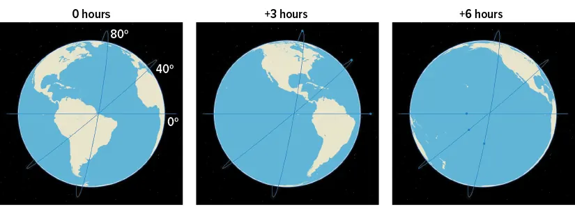
The orbital track remained unchanged as the Earth rotate beneath it, hence providing more coverage area for the satellite.
Classification by Eccentricity
- Circular orbit: Eccentricity describes the shape of an orbit. An orbit with low eccentricity, close to zero, is nearly circular. Most common orbits, including LEO, MEO, and GEO, are designed to be as circular as possible to maintain a constant altitude and consistent performance.
- Highly Elliptical Orbit (HEO): is an elongated orbit with high eccentricity. A satellite in this orbit experiences significant changes in altitude and speed during its journey. It moves very quickly when it is close to Earth (perigee) and very slowly when it is far away (apogee).
- One famous type of elliptical orbit is the Molniya orbit. Designed by the Soviet Union, this orbit has a high inclination (63.4 degrees) and a 12-hour period. A satellite in a Molniya orbit spends most of its time over high-latitude regions, such as Russia, making it suitable for communications in areas where geostationary satellites are low on the horizon.
The Kessler Syndrome
As the number of objects in orbit increases, particularly in the heavily used LEO region, so does the risk of collisions. Kessler Syndrome is a theoretical scenario where the density of objects in LEO becomes high enough that collisions between objects could create a cascade of further collisions. Each collision generates a cloud of debris fragments, which in turn increases the probability of more collisions.
If such a cascade were to occur, certain orbital regions could become so cluttered with high-speed debris that they would be unusable for future satellites and hazardous to crewed space missions. This concept highlights the importance of space traffic management and the development of practices such as de-orbiting defunct satellites and designing satellites to avoid creating new debris. Understanding and mitigating this risk is a focus of ongoing research in space sustainability.
If such a cascade were to occur, certain orbital regions could become so cluttered with high-speed debris that they would be unusable for future satellites and hazardous to crewed space missions. This concept highlights the importance of space traffic management and the development of practices such as de-orbiting defunct satellites and designing satellites to avoid creating new debris. Understanding and mitigating this risk is a focus of ongoing research in space sustainability.
Summary