What Determines Climate?
Climate describes the long-term pattern of weather in a particular region. While weather refers to conditions at a specific time, climate represents averages and variations measured over decades. Several factors influence a location's climate, including:
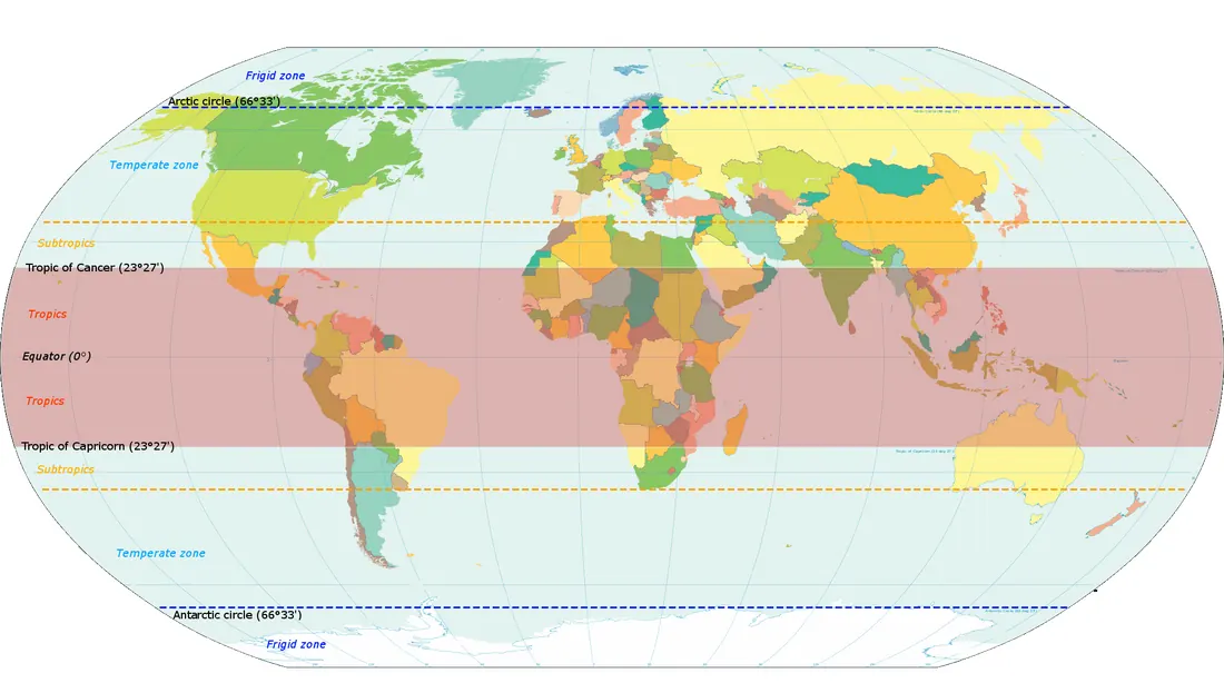
Latitude is a primary factor because it determines the angle at which sunlight strikes the Earth. The tropics, defined as the region between the Tropic of Cancer (23.5°N) and the Tropic of Capricorn (23.5°S), receive more direct sunlight throughout the year than higher latitudes, resulting in warmer temperatures with less seasonal variation.
Hong Kong is situated at approximately 22 degrees north latitude, placing it within the tropical zone geographically, as it lies south of the Tropic of Cancer. However, its climate is strongly modified by two factors: the vast Asian continent to the north and the monsoon wind system. For this reason, Hong Kong is often described as having a subtropical climate, referring to the seasonal contrast and occasional winter chill that result from continental influences, rather than a strict latitudinal definition.
The South China Sea to the south moderates temperatures, while the Asian landmass to the north serves as a source of cold, dry air in winter and intense heating that drives the summer monsoon.
- latitude,
- proximity to oceans,
- elevation, and
- atmospheric circulation patterns.
Latitude is a primary factor because it determines the angle at which sunlight strikes the Earth. The tropics, defined as the region between the Tropic of Cancer (23.5°N) and the Tropic of Capricorn (23.5°S), receive more direct sunlight throughout the year than higher latitudes, resulting in warmer temperatures with less seasonal variation.
Hong Kong is situated at approximately 22 degrees north latitude, placing it within the tropical zone geographically, as it lies south of the Tropic of Cancer. However, its climate is strongly modified by two factors: the vast Asian continent to the north and the monsoon wind system. For this reason, Hong Kong is often described as having a subtropical climate, referring to the seasonal contrast and occasional winter chill that result from continental influences, rather than a strict latitudinal definition.
The South China Sea to the south moderates temperatures, while the Asian landmass to the north serves as a source of cold, dry air in winter and intense heating that drives the summer monsoon.
A key driver of seasonal change is the Asian monsoon system. Monsoons are large-scale wind patterns that reverse direction between seasons due to the different heating and cooling rates of land and ocean. In summer, the heated land creates low pressure, drawing warm, moist air from the ocean, bringing southerly winds, high humidity, and abundant rainfall. In winter, the cooled land creates high pressure, driving cool, dry northerly winds from the continent.
Because Hong Kong lies near the northern edge of the tropics, it experiences distinct seasonal changes unlike locations closer to the equator. The winter monsoon can bring occasional cold surges, a feature not typical of purely tropical climates.
Because Hong Kong lies near the northern edge of the tropics, it experiences distinct seasonal changes unlike locations closer to the equator. The winter monsoon can bring occasional cold surges, a feature not typical of purely tropical climates.
Hong Kong's Seasonal Climate
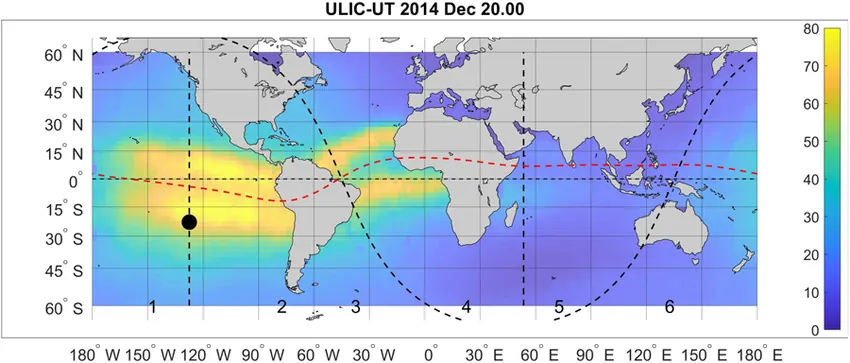
The sub‐solar point is indicated by a black circle, the solar and midnight meridians by straight dashed lines, the solar terminator by the curved dashed lines and the geomagnetic equator by the red dashed line. Study of the Weddell Sea Anomaly Using Novel Satellite Altimeter TEC Maps, Journal of Geophysical Research: Space Physics
October 2024 Francisco Azpilicueta
National University of La Plata
Hong Kong experiences distinct seasonal changes:
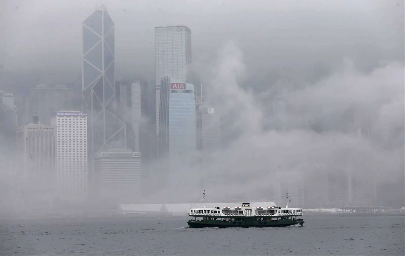 |
Spring (March to April) is a transition period. As the sun angle increases and the land warms, the winter monsoon weakens. Southerly winds become more frequent, bringing warm, moist air from the South China Sea. When this humid air encounters cooler surfaces, fog and drizzle can form, explaining the low visibility and humid conditions common in spring.
|
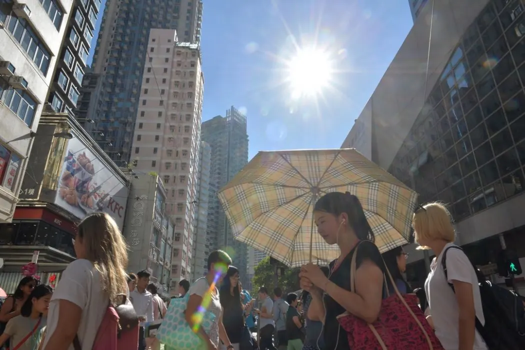 |
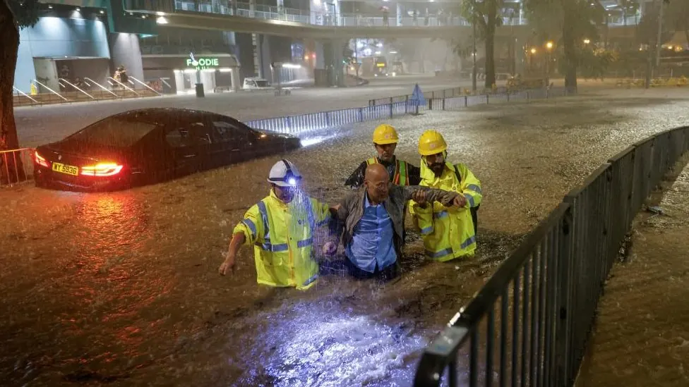
Summer (May to August) coincides with the peak summer monsoon. Prevailing southerly winds carry moisture evaporated from the ocean. Intense solar heating causes this warm, moist air to rise and condense, forming cumuliform clouds associated with showers and thunderstorms. High humidity reduces the body's cooling efficiency, making temperatures feel oppressive. A brief period of fine weather in July occurs when a subtropical high-pressure system temporarily suppresses cloud formation.
|
 |
Autumn (September to November) is the most active typhoon season in Hong Kong. While the winter monsoon begins to re-establish itself, with northerly winds gradually bringing drier air from the continent, the South China Sea remains warm enough to fuel tropical cyclones. These storms, often approaching from the east or southeast, can bring severe weather including strong winds, heavy rain, and storm surges. The combination of occasional typhoons and the gradual onset of drier northerly air makes autumn a season of contrast—pleasant weather between storms, but also the period of highest tropical cyclone risk.
|
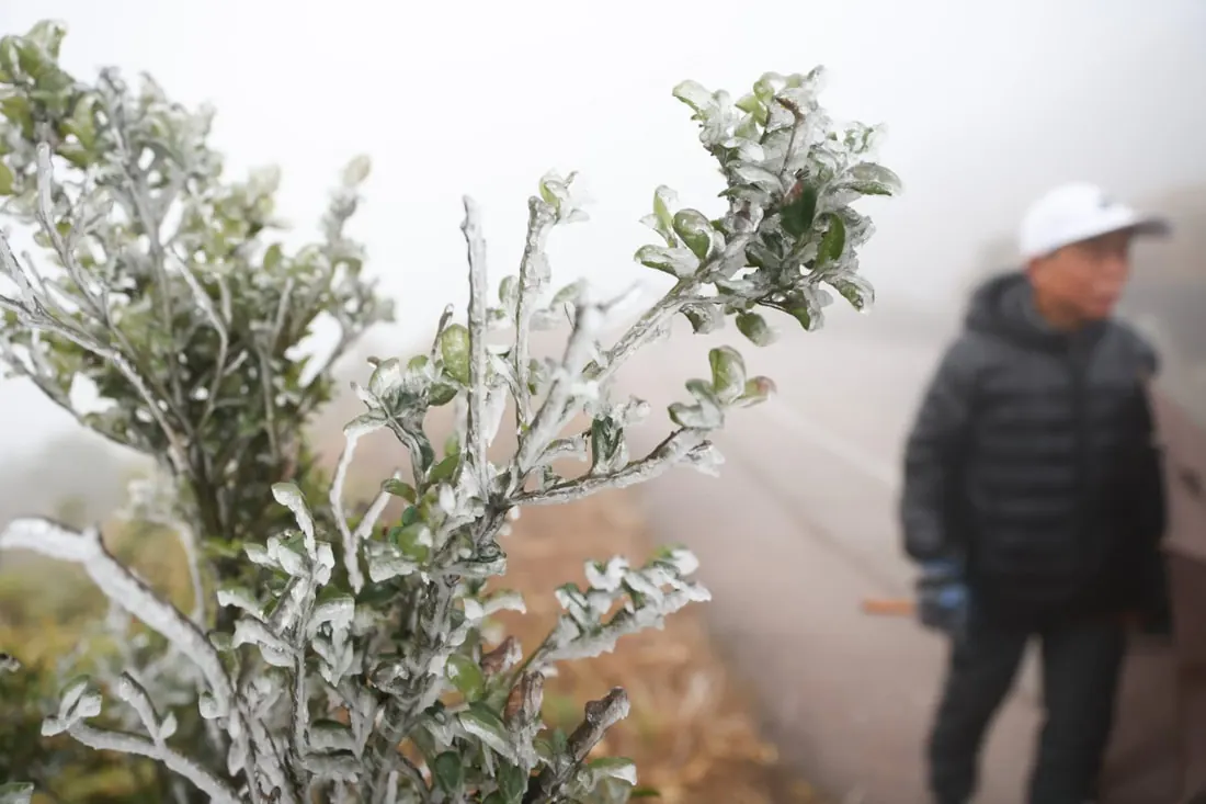 |
Winter (December to February) is dominated by the winter monsoon. Strong northerly or northeasterly winds bring cool, dry air from Siberia and northern China. The air remains dry as it has not passed over large bodies of water, explaining the low humidity and clear skies typical of Hong Kong winters. Occasional cold fronts can bring even colder air, sometimes lowering temperatures below 10°C. When these surges occur, the temperature difference between cold continental air and warmer sea surface can create instability, leading to cloud development and occasional rain.
|
Global Circulation Patterns Affecting Climate
Beyond the seasonal monsoon cycle, several large-scale systems influence global weather and climate patterns. These operate across ocean basins and can explain why some years are wetter, drier, hotter, or cooler than average in regions around the world, including Hong Kong.
Trade Winds
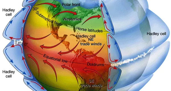
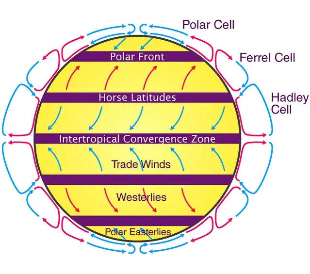
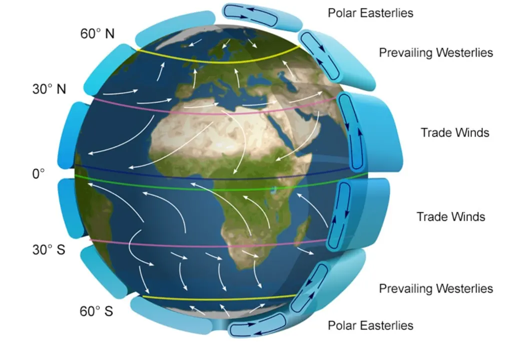
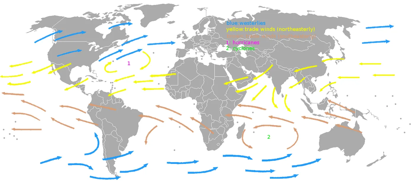
Trade winds are reliable easterly winds that blow from east to west in tropical regions, approximately between 30 degrees north and 30 degrees south latitude. In the Northern Hemisphere, they blow from the northeast, while in the Southern Hemisphere, they blow from the southeast. These winds are a surface component of large atmospheric circulation cells called Hadley cells, which transport heat from the equator toward higher latitudes. The name "trade winds" derives from their historical use by sailing ships conducting transoceanic trade, as their consistent direction made them reliable for navigation.
Trade winds play several important roles in the climate system. They drive ocean surface currents, transporting warm water toward the western side of ocean basins. They also steer tropical cyclones across the Atlantic and Pacific Oceans, influencing which regions are threatened by these storms. The strength of the trade winds is not constant; it varies naturally and is closely linked to the El Niño-Southern Oscillation phenomenon.
Trade winds are reliable easterly winds that blow from east to west in tropical regions, approximately between 30 degrees north and 30 degrees south latitude. In the Northern Hemisphere, they blow from the northeast, while in the Southern Hemisphere, they blow from the southeast. These winds are a surface component of large atmospheric circulation cells called Hadley cells, which transport heat from the equator toward higher latitudes. The name "trade winds" derives from their historical use by sailing ships conducting transoceanic trade, as their consistent direction made them reliable for navigation.
Trade winds play several important roles in the climate system. They drive ocean surface currents, transporting warm water toward the western side of ocean basins. They also steer tropical cyclones across the Atlantic and Pacific Oceans, influencing which regions are threatened by these storms. The strength of the trade winds is not constant; it varies naturally and is closely linked to the El Niño-Southern Oscillation phenomenon.
 |
 |
 |
 |
El Niño and La Niña
El Niño and La Niña are opposite phases of a climate pattern called the El Niño-Southern Oscillation (ENSO), which occurs in the tropical Pacific Ocean approximately every two to seven years. This pattern represents one of the most significant sources of year-to-year climate variability on Earth, affecting temperature and precipitation across the globe.
Under normal conditions, the trade winds blow from east to west across the tropical Pacific, piling warm surface water in the western Pacific near Indonesia and Australia. This causes sea level to be about one-half meter higher in the western Pacific than in the eastern Pacific. The warm water in the west fuels rising air and abundant rainfall, while cooler water off South America suppresses precipitation. Along the coast of Peru, the trade winds also drive upwelling, bringing cold, nutrient-rich water to the surface that supports productive fisheries.
El Niño and La Niña are opposite phases of a climate pattern called the El Niño-Southern Oscillation (ENSO), which occurs in the tropical Pacific Ocean approximately every two to seven years. This pattern represents one of the most significant sources of year-to-year climate variability on Earth, affecting temperature and precipitation across the globe.
Under normal conditions, the trade winds blow from east to west across the tropical Pacific, piling warm surface water in the western Pacific near Indonesia and Australia. This causes sea level to be about one-half meter higher in the western Pacific than in the eastern Pacific. The warm water in the west fuels rising air and abundant rainfall, while cooler water off South America suppresses precipitation. Along the coast of Peru, the trade winds also drive upwelling, bringing cold, nutrient-rich water to the surface that supports productive fisheries.
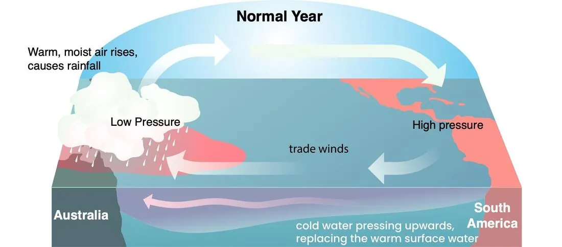
El Niño occurs when the trade winds weaken or reverse direction. Without strong winds pushing water westward, warm water sloshes back toward the central and eastern Pacific. Sea surface temperatures in the eastern Pacific rise above normal, sometimes by several degrees. This shifts the pattern of rainfall, bringing drought to regions that are normally wet, such as Australia and Indonesia, and flooding to normally dry areas like coastal Peru and Ecuador. The warmer ocean also alters atmospheric circulation patterns worldwide, affecting weather in North America, Africa, and beyond.
La Niña represents the opposite phase, where the trade winds are stronger than normal, enhancing the pile-up of warm water in the western Pacific and increasing upwelling of cold water in the eastern Pacific. Sea surface temperatures in the central and eastern Pacific become cooler than average. This typically brings increased rainfall to Australia and Southeast Asia, and drier conditions to the southwestern United States and parts of South America. For Hong Kong and southern China, La Niña years are sometimes associated with more active tropical cyclone seasons, though the relationship is complex and influenced by other factors.
La Niña represents the opposite phase, where the trade winds are stronger than normal, enhancing the pile-up of warm water in the western Pacific and increasing upwelling of cold water in the eastern Pacific. Sea surface temperatures in the central and eastern Pacific become cooler than average. This typically brings increased rainfall to Australia and Southeast Asia, and drier conditions to the southwestern United States and parts of South America. For Hong Kong and southern China, La Niña years are sometimes associated with more active tropical cyclone seasons, though the relationship is complex and influenced by other factors.
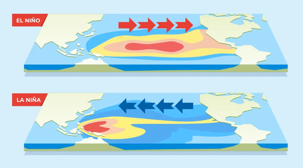
Between these extremes are neutral conditions, where ocean temperatures and atmospheric patterns are near their long-term averages. Forecasters monitor ENSO conditions continuously, as they can often predict the development of El Niño or La Niña seasons in advance, providing useful information for agriculture, water management, and disaster preparedness.
Thermohaline Circulation
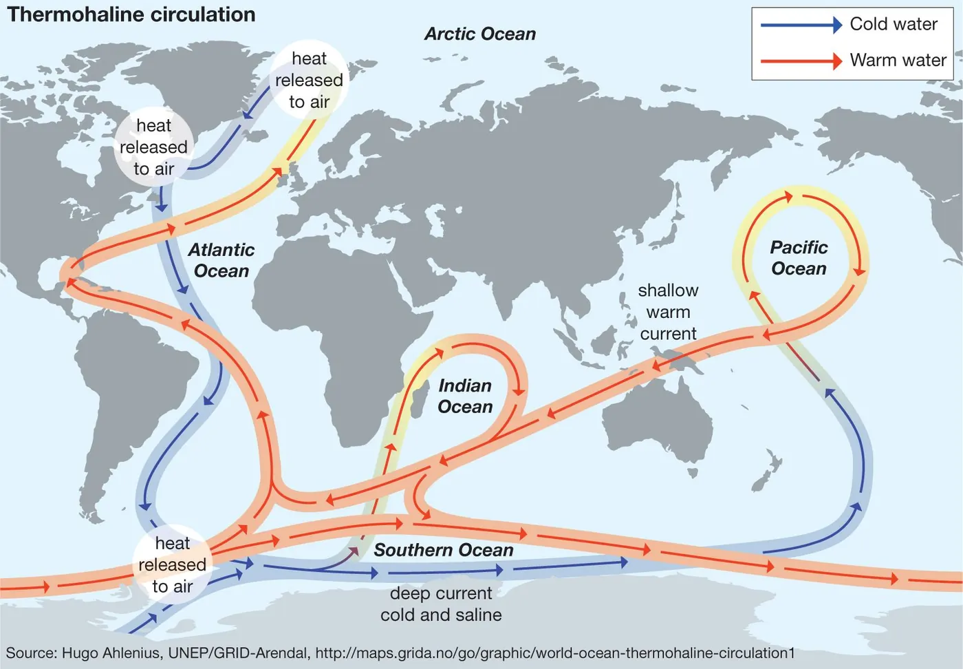
While trade winds and ENSO operate in the atmosphere and upper ocean over months to years, the thermohaline circulation is a much slower, deeper ocean current system that moves water throughout the global ocean on timescales of centuries. Its name derives from "thermo" (temperature) and "haline" (salinity), the two factors that determine seawater density and drive this circulation.
Cold, salty water is denser than warm, fresh water and tends to sink. In the North Atlantic, warm surface water carried northward by currents such as the Gulf Stream cools and evaporates, becoming colder and saltier. This dense water sinks to great depths, forming North Atlantic Deep Water, which then spreads southward throughout the Atlantic and into other ocean basins. Similarly, around Antarctica, cold, salty water sinks to form Antarctic Bottom Water, which flows northward along the seafloor. This sinking in the North Atlantic and Southern Ocean drives a global-scale circulation sometimes called the "global conveyor belt," connecting all the world's oceans.
The thermohaline circulation plays an important role in regulating Earth's climate. It transports vast amounts of heat from the tropics toward the poles, influencing temperatures in regions such as western Europe. It also moves dissolved gases and nutrients throughout the ocean, affecting marine ecosystems and the global carbon cycle. Changes in this circulation, potentially caused by melting ice adding fresh water to the North Atlantic, could have significant climate implications, though such changes are generally expected to occur over long timescales.
While trade winds and ENSO operate in the atmosphere and upper ocean over months to years, the thermohaline circulation is a much slower, deeper ocean current system that moves water throughout the global ocean on timescales of centuries. Its name derives from "thermo" (temperature) and "haline" (salinity), the two factors that determine seawater density and drive this circulation.
Cold, salty water is denser than warm, fresh water and tends to sink. In the North Atlantic, warm surface water carried northward by currents such as the Gulf Stream cools and evaporates, becoming colder and saltier. This dense water sinks to great depths, forming North Atlantic Deep Water, which then spreads southward throughout the Atlantic and into other ocean basins. Similarly, around Antarctica, cold, salty water sinks to form Antarctic Bottom Water, which flows northward along the seafloor. This sinking in the North Atlantic and Southern Ocean drives a global-scale circulation sometimes called the "global conveyor belt," connecting all the world's oceans.
The thermohaline circulation plays an important role in regulating Earth's climate. It transports vast amounts of heat from the tropics toward the poles, influencing temperatures in regions such as western Europe. It also moves dissolved gases and nutrients throughout the ocean, affecting marine ecosystems and the global carbon cycle. Changes in this circulation, potentially caused by melting ice adding fresh water to the North Atlantic, could have significant climate implications, though such changes are generally expected to occur over long timescales.
Tropical Cyclones and Their Behaviour
 |
 The Climatological Analysis of Typhoon Tracks, Steering Flow, and the Pacific Subtropical High in the Vicinity of Taiwan and the Western North Pacific
by Chih-wen Hung *,Ming-Fu Shih andTe-Yuan Lin
Department of Geography, National Taiwan Normal University, Taipei 106, Taiwan
|
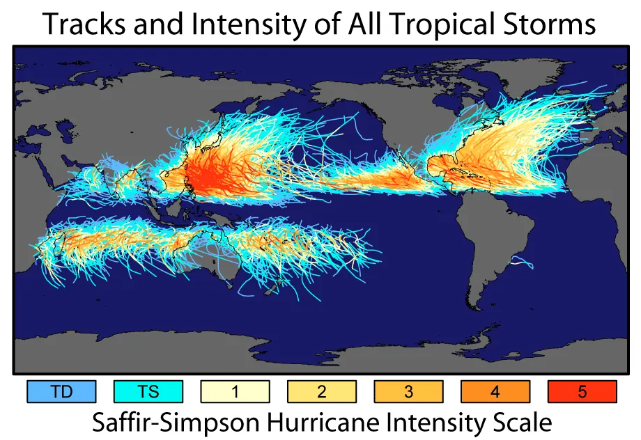
Tropical cyclones are among the most significant weather events affecting Hong Kong. Their formation, movement, and intensity changes are governed by several factors.
Tropical cyclones form over warm ocean waters where sea surface temperatures exceed about 26.5°C. This warmth provides the energy that drives the storm through evaporation and subsequent condensation. They typically develop between 5 and 20 degrees latitude, where the Coriolis effect is strong enough to initiate rotation. Hong Kong, at 22 degrees north, lies near the northern edge of the main formation region for western North Pacific typhoons. Storms that form closer to the equator may move northward and affect Hong Kong as they approach.
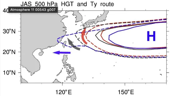
The steering of tropical cyclones is primarily influenced by large-scale atmospheric circulation patterns. In the western North Pacific, this steering is largely controlled by the subtropical high-pressure system. When the subtropical high extends westward, its clockwise circulation tends to steer cyclones toward the Philippines, southern China, or Vietnam. When the high retreats eastward, cyclones may recurve toward Japan or Korea. The position and strength of this high-pressure system at any given time determines whether a cyclone threatens Hong Kong.
Intensity changes are influenced by several factors.
Tropical cyclones form over warm ocean waters where sea surface temperatures exceed about 26.5°C. This warmth provides the energy that drives the storm through evaporation and subsequent condensation. They typically develop between 5 and 20 degrees latitude, where the Coriolis effect is strong enough to initiate rotation. Hong Kong, at 22 degrees north, lies near the northern edge of the main formation region for western North Pacific typhoons. Storms that form closer to the equator may move northward and affect Hong Kong as they approach.
The steering of tropical cyclones is primarily influenced by large-scale atmospheric circulation patterns. In the western North Pacific, this steering is largely controlled by the subtropical high-pressure system. When the subtropical high extends westward, its clockwise circulation tends to steer cyclones toward the Philippines, southern China, or Vietnam. When the high retreats eastward, cyclones may recurve toward Japan or Korea. The position and strength of this high-pressure system at any given time determines whether a cyclone threatens Hong Kong.
Intensity changes are influenced by several factors.
- Warm ocean water provides energy for intensification.
- Low vertical wind shear allows the storm structure to remain organized and strengthen.
- Conversely, passage over cooler water, interaction with land, or high wind shear can cause weakening.
Activity: Plotting data on a Chart
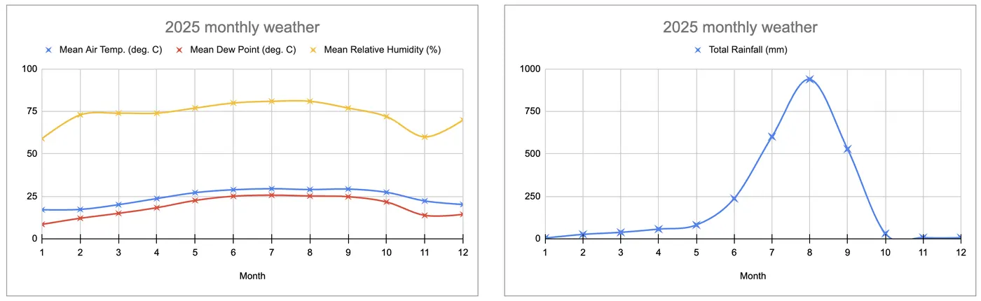
Compile historical weather data from HKO to show the monthly trend in Temperature, Dew Point, Humidity, and Rainfall.
|
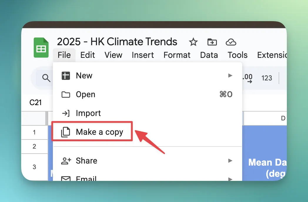
Step 1: Setup Your Lab (Make a Copy)
Before you can analyze the data, you need your own digital workbook.
|
 |
|
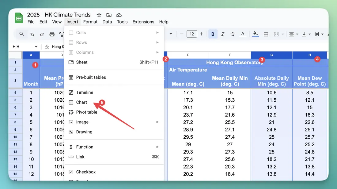
Step 2: Create the Chart
First, let’s see what the raw data looks like across the 12 months.
|
 |
|
Step 3: Customise the Chart
|
 |