Introduction
This chapter introduces the systems and models used to map the positions and movements of objects in the sky. We will begin with the coordinate systems that form the foundation of celestial observation, followed by the astronomical events that define our seasons and key reference points.
Celestial Coordinate Systems
To locate objects in the sky, astronomers use coordinate systems, much like using latitude and longitude to specify a location on Earth. Two primary systems are used: the Horizon System, which is local to the observer, and the Equatorial System, which provides fixed coordinates for celestial objects.
- The Horizon System (Altitude-Azimuth)
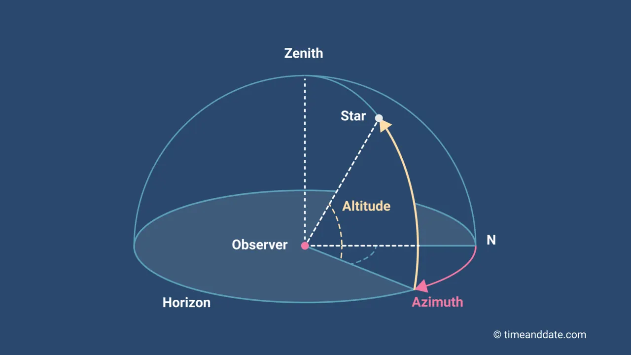
This system is based on the observer's local horizon and is therefore specific to the observer's location and the time of observation. An object's position changes continuously in this system as the Earth rotates.- Altitude is the angular height of an object above the horizon. It is measured in degrees, from 0° at the horizon to 90° at the zenith (the point directly overhead). For objects below the horizon, start from 0° down to -90° at the nadir (which is directly beneath the observer).
- Azimuth is the angular distance measured clockwise around the horizon from a reference direction, typically true north. It is measured in degrees from 0° (North), through 90° (East), 180° (South), and 270° (West).
Activity 1: The Horizon System (Altitude-Azimuth)
This system is local to you, the observer. Your reference points are the horizon and the North direction. At your seat, for each imaginary star below, first face North, then turn to the correct azimuth, and finally point your arm up to the correct altitude.
This system is local to you, the observer. Your reference points are the horizon and the North direction. At your seat, for each imaginary star below, first face North, then turn to the correct azimuth, and finally point your arm up to the correct altitude.
- Star Alpha: Azimuth: 180°, Altitude: 30°
- Star Beta: Azimuth: 90°, Altitude: 60°
- Star Gamma: Azimuth: 270°, Altitude: -60°
- The Equatorial System
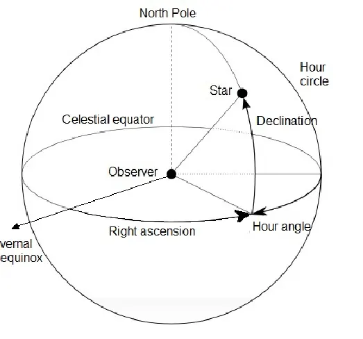
To create a fixed map, the Equatorial System is used. It is a projection of Earth's latitude and longitude system onto the celestial sphere and is independent of the observer's location or the time of day. This means every star has a fixed set of equatorial coordinates.- Declination (Dec) is the celestial equivalent of latitude. It measures an object's angular distance north or south of the celestial equator, in degrees. The celestial equator is 0° declination, the north celestial pole is +90°, and the south celestial pole is -90°.
- Right Ascension (RA) is the celestial equivalent of longitude. It measures the angular distance eastward along the celestial equator from a starting point known as the Vernal Equinox. Right Ascension is measured not in degrees, but in hours, minutes, and seconds, from 0h to 24h.
Activity 2: The Equatorial System
This system is a fixed map of the sky. Your reference points are the celestial equator and the Vernal Equinox point marked in the room. Remember, Right Ascension is measured eastward from the Vernal Equinox (0h to 24h), and Declination is measured above or below the celestial equator. Stand in the center of the room and use the reference lines established by your instructor.
This system is a fixed map of the sky. Your reference points are the celestial equator and the Vernal Equinox point marked in the room. Remember, Right Ascension is measured eastward from the Vernal Equinox (0h to 24h), and Declination is measured above or below the celestial equator. Stand in the center of the room and use the reference lines established by your instructor.
- Star Delta: Right Ascension: 0h, Declination: +20°
- Star Epsilon: Right Ascension: 6h, Declination: 0°
- Star Zeta: Right Ascension: 18h, Declination: -30°
Solstices and Equinoxes
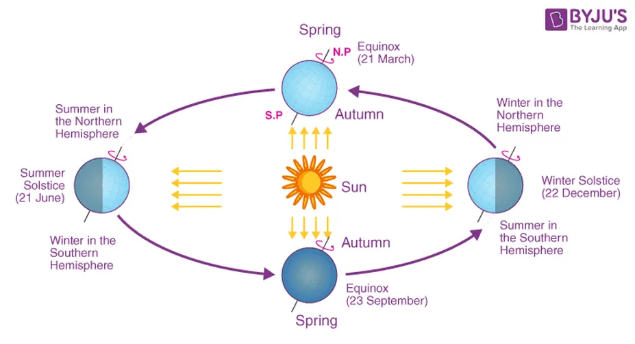
The Equatorial System's reference point, the Vernal Equinox, is one of four significant points in Earth's annual orbit around the Sun. These points, caused by the tilt of Earth's axis, mark the change of seasons.
- Equinoxes: There are two equinoxes in a year, which occur when the Earth's axis is tilted neither toward nor away from the Sun, resulting in nearly equal lengths of day and night across the globe.
- The Vernal Equinox (around March 21) marks the start of spring in the Northern Hemisphere. At this moment, the Sun crosses the celestial equator moving from south to north. This intersection point is the zero point (0h) for Right Ascension.
- The Autumnal Equinox (around September 23) marks the beginning of autumn in the Northern Hemisphere, as the Sun crosses the celestial equator moving from north to south.
- Solstices: The solstices mark the points in Earth's orbit where the tilt of its axis is most inclined toward or away from the Sun.
- The Summer Solstice (around June 21) is the longest day of the year in the Northern Hemisphere, marking the start of summer. The Sun reaches its most northerly point in the sky.
- The Winter Solstice (around December 22) is the shortest day of the year in the Northern Hemisphere, marking the start of winter. The Sun is at its most southerly point.
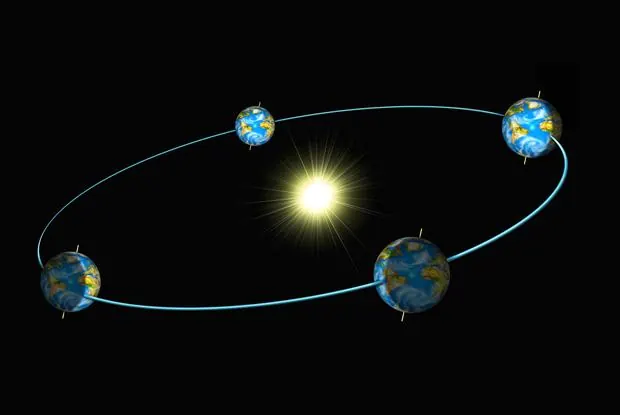
The starting point for Right Ascension is a fixed direction in space called the Vernal Equinox, which acts as the "Prime Meridian of the sky." This direction is defined by the Sun's exact position as it crosses the celestial equator moving north on the first day of spring (around March 21st). Though the Sun is only at this 0h "starting line" on that one day, the Vernal Equinox itself remains the constant and universal reference point for the entire celestial coordinate system all year round.
Activity: Tracking the Stars with Alt-Az Coordinates
In the following activity, we will learn how to locate celestial objects using the Horizontal Coordinate System (Azimuth and Altitude).
Stellarium-Web is a fantastic tool for this because it doesn't require any installation. To help your students find Azimuth (Az) and Altitude (Alt), you can structure an activity around three levels: Setup, Discovery, and Calculation.
Click Image to access Web App
Part 1: Setting the Stage
Before finding coordinates, students must ensure they are "standing" in the right place and time.
Before finding coordinates, students must ensure they are "standing" in the right place and time.
- Open: Go to stellarium-web.org.
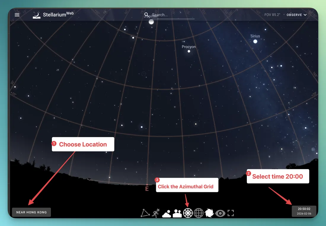
- Location: Click the location bar (bottom left). Ensure "Use auto-location" is on, or search for your specific city.
- Time: Click the clock (bottom right). For this activity, set it to 8:00 PM (20:00) tonight.
- The Grid: On the bottom toolbar, click the Azimuthal Grid icon (it looks like a circular web). This shows the coordinate lines in the sky.
Part 2: Understanding the "Map"
Two definitions to students before they start:
Two definitions to students before they start:
- Azimuth (Az): The direction around the horizon. (North = 0°, East = 90°, South = 180°, West = 270°).
- Altitude (Alt): The height above the horizon. (Horizon = 0°, Zenith/Straight up = 90°).
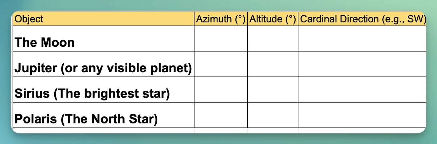
Part 3: Student Mission (The Worksheet)
Students to find the following objects and record their coordinates.
Students to find the following objects and record their coordinates.